
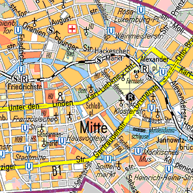
Die Übersichtskarte von Berlin 1:50 000 (ÜK50) stellt das gesamte Gebiet Berlins und das nähere Umland auf Basis der amtlichen Geobasisdaten ATKIS dar.
Informationen zum Datensatz
-
Kategorie:
-
Geographische Abdeckung:
-
Geographische Granularität:
-
Zeitliche Granularität:
-
Veröffentlicht:01.06.2014
-
Aktualisiert:01.06.2021
-
Veröffentlichende Stelle:
-
E-Mail Kontakt:gerlind.blanke AT senstadt.berlin.de
-
Kommentare:0

Ressource(n)
Endpunkt-Beschreibung des WMS-Service
Maschinenlesbare Endpunkt-Beschreibung des WMS-Service. Weitere Informationen unter https://www.ogc.org/standards/wms
Format:
WMS
Sprache:
Deutsch
API-Endpunkt des WMS-Service
API-Endpunkt des WMS-Service. Weitere Informationen unter https://www.ogc.org/standards/wms
Format:
WMS
Sprache:
Deutsch
Serviceseite im FIS-Broker
Aufruf des Geoportals Berlin mit Darstellung der Karte und weiterer Metadaten
Format:
HTML
Sprache:
Deutsch
Inhaltliche Beschreibung
Inhaltliche Beschreibung
Format:
HTML
Sprache:
Deutsch