Digitale Color-Infrarot-TrueOrthophotos 2020 (TrueDOP20CIR) - Sommerbefliegung - [WMS]

Vorschaugrafik zu Datensatz 'Digitale Color-Infrarot-TrueOrthophotos 2020 (TrueDOP20CIR) - Sommerbefliegung - [WMS]'

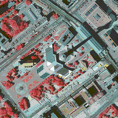
Bei den Daten handelt es sich um farbige digitale Infrarot-TrueOrthophotos (TrueDOP20CIR) für das gesamte Berliner Stadtgebiet im Blattschnitt 2 km x 2 km, Bodenauflösung 0,20 Meter bei einer Lagegenauigkeit von +/- 0,4 Meter. Der Flughafen BER ist auch enthalten.

Vorschaugrafik zu Datensatz 'Digitale Color-Infrarot-TrueOrthophotos 2020 (TrueDOP20CIR) - Sommerbefliegung'

Informationen zum Datensatz

Ressourcen

Endpunkt-Beschreibung des WMS-Service

WMS

Maschinenlesbare Endpunkt-Beschreibung des WMS-Service. Weitere Informationen unter https://www.ogc.org/standards/wms

  • Format: WMS

API-Endpunkt des WMS-Service

WMS

API-Endpunkt des WMS-Service. Weitere Informationen unter https://www.ogc.org/standards/wms

  • Format: WMS

Serviceseite im FIS-Broker

HTML

Aufruf des Geoportals Berlin mit Darstellung der Karte und weiterer Metadaten

  • Format: HTML